A Walk Round Old Yardley Village
November 1979, Updated May 2010
The village is a remarkable survival, and retains more of its rural atmosphere than any other village now incorporated within Birmingham. recognising this fact the area, which has been designated a Conservation Area since 16th July 1969, was upgraded to Outstanding category in 1976, the only one so far in the city.
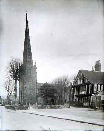
The Parish Church, St Edburgha's, was the focus of the ancient parish of Yardley, which covers 7,590 acres, and until 1911 part of Worcestershire. The settlement probably originates in the late Saxon period, on the lighter soils of the northern part of the parish, although the first relable indication as a nucleated settlement around the church is provided by 13th century deeds.
Until the early 19th century the village consisted of a series of small farmhouses, or cottages with barns and other agricultural buildings, around farmyards with enclosed crofts behind, and scattered land in open fields in the area, now occupied by Yardley Fields Road.
From about 1800 many village buildings were rebuilt and only Church Farm survives.
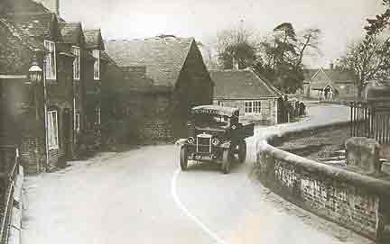
Taking the Route from Blakesley hall, walk down Blakesley Road to the juction of Stoney Lane, known as Stonystret in the 14th century, turn left at the junction of Church Road, on the right was once "The Talbot Inn"a 19th century building. Here the Trustees of the Charity Estates met to distribute dole money.
On the left beyond the footpath sign posted Abbess Grove is number 423-425, which has a complex building history over 260 years. It began in 1710 as a cottage built for a local wheelwright, Thomas Roades. To this were added rear wings, and in the 1850's a butcher's shop and slaughter house, with the iron barred window. Then lying back from the road is the shop front, which was by the Harrison family until 1957.
Opposite is the former Trust School of the early 16th Century. This building has been identified with "the church howse" being built in 1512 becoming a school house. The school closed in 1908. Beyond the timber framed block, 422 and 424, early 19th century addition built for the school master.
In front of the low wall to the churchyard were situated the wooden "Stocks and Whipping Post", removed in the 19th century.
The Churchyard was cleared of all gravestones, between 1959-60, except of the schoolmaster, James Chell.
The Church itself has many treasurers, and is well worth a tour around. The 15th century south porch shows incised marks in the base of the tower, which is said to have been produced by local sharpening their arrows.
On the left is 431, descibed a newly built in 1796, the the side is a coach house.
431 was a general store until the 1960's.
Then Cottage institute 1882. It began as a meeting hall to encourage gardening and industrial work for villagers. The Instutues occupies the orginal site of the ring of bells.
Adjoining 435 a symmetrical brick cottage built in 1826 by the Yardley Charty Estate Trustees for local Blacksmith, John Leake.
437-443 built soon after 1894 on the site of six early 19th century cottages, in turn built on the site of a small farmhouse.
Beyond the opening to Church Terrace 445-447, which began life in the late 18th century as a malthouse, but was converted to cottages in the 1850's
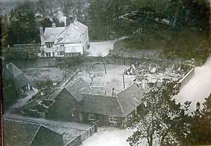
Then 451 Church Farm , other wise Tile House Farm. The site was given to the Charity Trust in 1463 by local tilemaker Robert Robyns. The Trust's accounts show how the present farmbuildings were built in the early 19th century, starting in the 1820's with the cowhouse, whose gable fronts the street, beyond is the barn of 1848 and wagon hovel of 1853. Then the farmhouse itself, rebuilt in 1837, and to its right the stable with a loft over built with a pair of upper crucks, and finally the "Smithy"
The vicarage beyond was rebuilt in 1960, since demolished , here today you will see "Yardley Grange Nursing Home", Opened in 2003 by Baroness Morris, former MP for Yardley, and run by Yardley Great Trust.
On the corner of School Lane is the former Sunday School, opened in 1832.
Beyond are the Trust's Almshouses which stood beside the Trust School on the Southern edge of the churchyard until 1904.
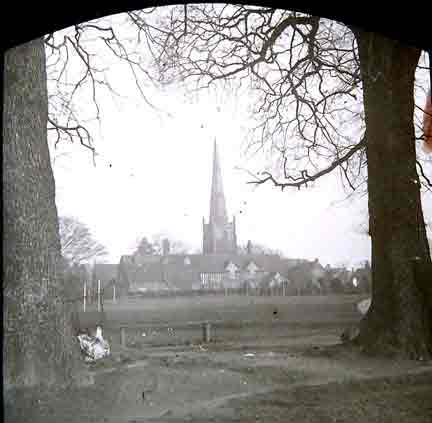
Walking back through the Park, there is a copse of trees. The trees mark the island of a former medieval moated side, known as Rents Moat, and thought to have been inhabited by the Allestree family in the Middle Ages.
Following the path will lead back to Church Road.
photograph Canon Cochrane
"A Walk Round Old Yardley Village"
prepared by Stephen Price, City Museum and Art Gallery, November 1979, Updated May 2010 by Robert Jones